Find Your Daily Voice
Tag: National Weather Service
Storm Cuts Power To Thousands In NJ (Update)
Thousands of New Jersey residents were without power Thursday, April 4 following a nasty storm that brought gusty winds and heavy rain to the region on Wednesday, April 3.
As of 8 a.m., 8,000 Monmouth County residents were without power mainly in Freehold, Highlands, and Middletown (4,000), according to JCP&L.
In Bergen County, more than 2,000 PSE&G customers had no power mostly in Englewood, Englewood Cliffs, and Teaneck.
In Essex County, 1,063 PSE&G customers were in the dark, the majority in Irvington.
In Morris County, 3.000 customers were without power mostly in Jeff…
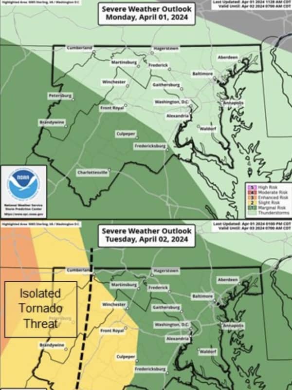
Long-Duration Storm: Be Ready For Wintry Mix, Power Outages, Flooding, Hochul Warns NYers
Ahead of an upcoming storm system expected to last several nights, New York Gov. Kathy Hochul is urging residents across the state to prepare for snow, heavy rains, power outages, and flooding.
According to the latest predictions, the storm is expected to arrive in the Hudson Valley, Capital Region, and Long Island on Tuesday, April 2, and continue through Thursday night, April 4, bringing poor travel conditions and likely power outages along with it, Hochul announced.
Related Report - Strengthening Nor'easter Will Bring Heavy Rain, Gusty Winds, Up To 2 Feet Of Snow In Spo…
Coastal Flood Warning In Effect For Jersey Shore Due To Offshore Storm, Full Moon
Many parts of New Jersey are under a coastal flood warning with an offshore storm and a full moon expected to fuel high tides, forecasters said.
The National Weather Service issued the coastal flood warning in Atlantic, Burlington, Cape May, Middlesex, Monmouth, and Ocean counties at 6 a.m. on Monday, Mar. 25. The NWS said the warning would be in effect until 2 p.m. on Tuesday, Mar. 26.
A storm out in the Atlantic Ocean will increase offshore wind speeds and make waves larger, according to the NWS. That will combine with Monday night's full moon to create "widespread tidal flooding."
The w…
Split Storms Combine: Inch Per Hour Of Rain Could Fall In Nasty Weekend Storm, Forecasters Say
Much of the region is under a flood watch ahead of a heavy rain storm expected to arrive Friday night, March 22 and last through Saturday, March 23, the National Weather Service says.
A flood watch east of the Blue Ridge is in effect from 2 a.m. to 2 p.m. Saturday, March 23, where up to an inch of rain per hour could fall, enhancing the threat of flooding, according to the NWS.
The Flood Watch has been expanded to cover most locations east of the Blue Ridge. This is in effect on Sat 2 AM-2 PM... Posted by US National Weather Service Baltimore/Washington on Friday, March 22, 2024
"A…
Snow Squalls Smack NJ, Temps To Plummet (Video)
The first day of spring is behind us, but winter seems to be sticking around.
Snow and rain showers were possible Wednesday evening, March 20, with some snow squalls already having smacked the northernmost parts of New Jersey.
From a spotter in High Point earlier, around 4 PM, where 1 to 2" of snow fell quickly in northwest Sussex County NJ, as... Posted by US National Weather Service Philadelphia/Mount Holly on Wednesday, March 20, 2024
According to the National Weather Service, flurries were possible in Warren, Sussex, and Morris counties in New Jersey; and across the Lehigh Vall…
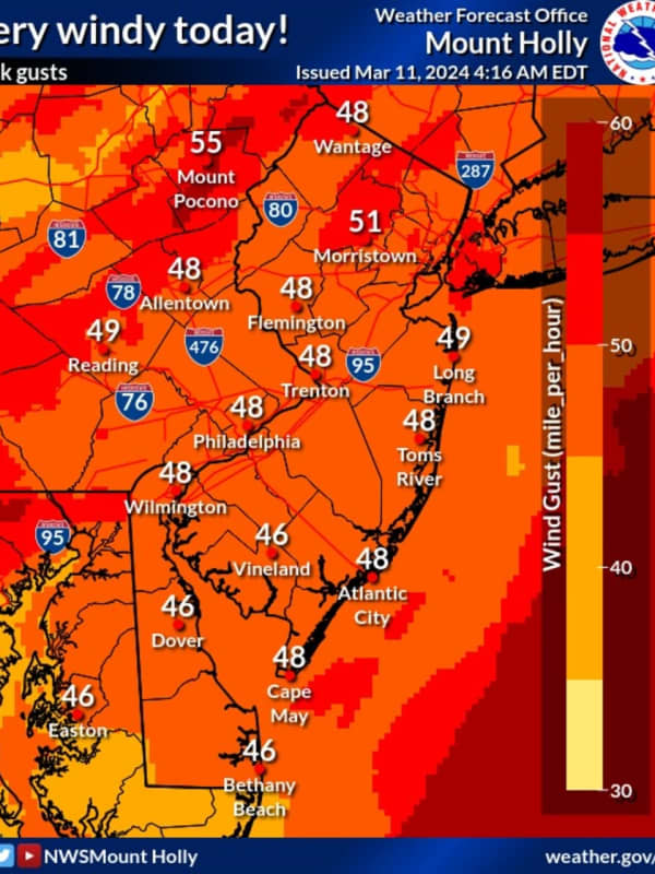
50 MPH Winds Knock Power To More Than 30K New Jersey Residents
Wind gusts nearing 50 miles per hour left thousands of New Jersey residents without power Monday, March 11.
According to the National Weather Service, winds are expected to die down in the evening with a wind advisory in effect until 11 p.m.
Skies will be mostly cloudy with a high near 50.
As of 4:15 p.m., the following areas did not have power:
JCP&L:
Hunterdon County: 4,264 without power mostly in Bethlehem, Glen Gardner, Hampton, Hampton, High Bridge, Lebanon, Readington
Middlesex County: 8,359 without power mostly in Monroe Township
Morris County: 10,049 mostly in…
Snow Possible In Parts Of Maryland, Virginia, Forecasters Say
Say it ain't snow.
Some parts of the DMV region may see another round of winter weather, as a fresh storm is set to head toward the area, according to forecasters.
5 PM Radar Update: Some quick moving cells are producing heavy rain, pea-sized hail, and frequent lightning. In particular, the areas within the orange polygons are most likely to see such storms. These are generally moving toward the NE at 60-65 mph. #MDwx #VAwx #DCwx #WVwx pic.twitter.com/Ozhu7VOBct — NWS Baltimore-Washington (@NWS_BaltWash) March 9, 2024
The National Weather Service issued an alert on Saturday, March 9, a…
Eversource Preparing For Power Outages, Downed Trees As Storm Intensifies In CT
As a strong storm system brings gusty winds and heavy rain to Connecticut, Eversource is preparing crews to respond to any power outages, downed trees, or other damage caused by the weather.
The storm system, which arrived on Wednesday, Feb. 28, is bringing powerful wind gusts of 25 to 25 miles per hour to the state and is set to continue overnight into Thursday, Feb. 29, according to predictions from the National Weather Service.
Related Report - Potent Storm Arrives: These Areas Expected To See 50 MPH Wind Gusts, Scattered Power Outages
Because these conditions could ver…
Snow, Hail Could Be Part Of Damaging Mid-Week Storm Headed To NJ, PA: Forecasters
Forecasters are tracking a gusty storm bringing rain and some snow to parts of New Jersey and Pennsylvania.
Rain is expected to begin across both states Tuesday evening, Feb. 27, and continue through Wednesday morning, Feb. 28, the National Weather Service says.
☔️ Multiple rounds of rain & storms will occur across central PA through Wednesday evening, Stay Weather Aware!
1⃣: Tues... Posted by US National Weather Service State College PA on Tuesday, February 27, 2024
While temperatures on Wednesday could reach a high of 60, a steep drop is expected in the evening to around 30, …
Forecasters Were Way Off: 13 Inches Of Snow Fell Unexpectedly In NJ, PA Towns
Four inches of snow at most was expected in the second snow storm of the week in New Jersey and Pennsylvania.
But much more fell.
In the Friday, Feb. 16 and Saturday, Feb. 17 storm, up to 13 inches of snow fell in some towns across the region, according to the National Weather Service.
Here's who got the most snow, according to the National Weather Service:
ATLANTIC, NJ: Beuna Vista, 3.3 inches; Hammonton, 2.8 inches; Somers Point, 2.2 inches
BERKS, PA: Lyons, 12 inches; Fleetwood, 9 inches; Blandon, 8.5 inches
BERGEN, NJ: Westwood 3 inches; Fair Lawn 2.5 inches; River Vale 2 …